Transformed Human Landscape


The 9-foot project changed the way people used and interacted with the Upper Mississippi River. Fertile floodplain farmsteads were flooded. Independent fisherman, foresters, and mussel-harvesters lost their mills and fishing grounds. Land-owners were given months to leave - with compensation - and begin again elsewhere. Depression-era squatters did not have that option, nor did the many tenant-farmers and sharecroppers who worked other people’s lands along the floodplain. Small town waterfronts were forced to pile high levees against increasing floodwaters. Cooperative drainage districts had to “levee up” too as more and more water backed up in their fields. Federal authority and standing water dissolved communities.

But of course people keep using the river - riverside homes have given way to seasonal recreation cabins and public marinas. In the fall, a mighty migration of duck and deer hunters infiltrate the quiet forests and islands. Fisherman are found year round - sometimes trolling along in jonboats, other times hunkered over a hole in the ice. And yes, some people do still live along the river, unprotected by levees and forever wary of high water.

Depression-era Upper Mississippi River newspapers were bullish on the 9-foot project’s economic and social impact. The Moline Dispatch proclaimed “unemployment problems … will be materially lessened during the subsequent twelve months because of lock and dam construction projects in the river” (Moline Dispatch. August 10, 1935). The true worth of the project, they believed, wouldn’t be realized for some time. “The value of the 9-foot channel, it is predicted, will continue far after the present generations with shipments… from this community along the Mississippi area going to all parts of the world via water” (ibid). In fact, riverfront towns up and down the Mississippi River would enjoy increased freight traffic and reduced rates which had been “the disadvantage that these cities have had as their handicaps for many years” (Rock Island Argus. November 24, 1933). For communities along the Upper Mississippi, the 9-foot project would be transformative.

And it was.

Two Mississippi examines this transformation across a series of broad categories. In the Field Notes section, I further detail this transformation on the landscape.

Ghosts on the Landscape - When you walk through the Upper Mississippi floodplain forest it is easy to feel like you are breaking new ground. It’s public land but I’ve rarely seen another person. A walk along the Upper Mississippi shoreline is, in many cases, a walk alone.

But if you look closely, you can see evidence of a past human existence. Lichen-covered foundations trace boundary lines around lost homes. Crumbled brick chimneystacks and the occasional bed-frame lie half submerged in nearly a century of silt. Old roads have given way to backwater sloughs. If you look through the right lens, you can see these ghosts on the landscape - the hidden architecture of human activity lost in the 9-foot project floodscape.

Land Use: An Abandoned Agricultural Landscape - The Upper Mississippi floodplain was desirable agricultural land. Centuries of spring floods filled the landscape with silty loam. Early homesteaders flocked to the more elevated portions of the floodplain. But by the late 19th century, land owners formed cooperative drainage districts, built levees, began pumping water from the floodplain, and farmed.

The 9-foot project largely put an end to farming inside of the flood easement boundary - there were a few holdouts. Farmers that held title to their land were offered settlements for their land and property. Their substantial farmsteads were sold to the highest bidder for scrap. If there were no bids, buildings were burned. Tenant farmers and sharecroppers had to simply vacate. Floodplain communities simply disappeared.

The ecological legacy of this transition is troubling. Invasive species have taken hold of former agricultural sites. And maple trees. Maples dominate where corn once stood.

Land Use: Continuing the Agricultural Legacy - Large-scale agriculture is still very much practiced on the margins bordering 9-foot project land. It’s highly productive land when it remains dry - but that happens less and less these days. Many farmers use levees and they provide protection most years. Others expanded and deepened drainage ditches to move water off of their fields quickly. But high water occasionally seeps in behind levees and overtops the ditches.

Land Use: Transportation Systems - The Army Corps removed the majority of Upper Mississippi River floodplain settlers. Roads and trails that connected these communities faded into the forest. Some dirt roads transitioned to gullies and small sloughs; water moved quickly along abandoned road cuts and eroded them easily.

Yet some trails and roads have been improved. This is rare and only occurs when the former farm road cuts through the public land to a shoreline campground or boat launch, when it leads to leased recreation cabins, or connects the occasional small town or riverfront community. Bridges and railroads modernized with the years.

Land Use: Urban Shorelines - Riverfront shorelines underwent their own transformation. High water required higher levees. Property directly along the shoreline became public land. Managers transformed that public land into recreation landscapes with camping, marinas, and dredge-sand beaches. Managers also abandoned public land and left it to collect the effluvia of flood after flood. Excepting large grain and gravel elevators, business and industry crouched behind levees and retreated from the urban shoreline.

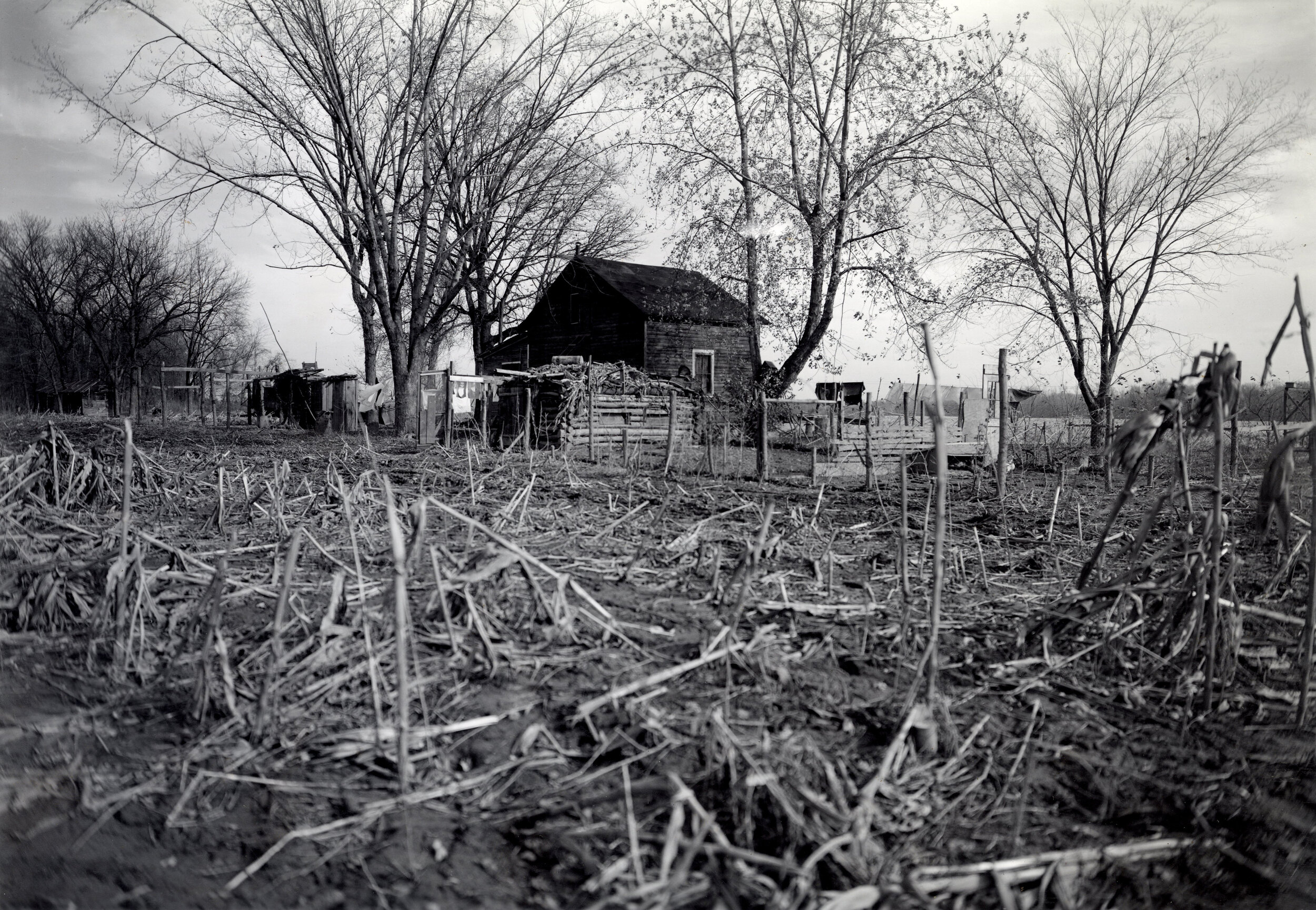
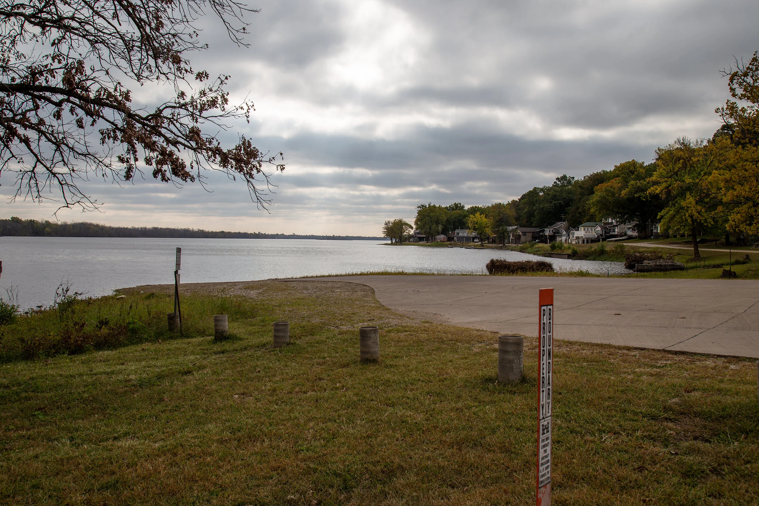
Land Use: Recreational Landscapes - The 9-foot project initiated a land use shift away from settled, year-round use towards seasonal recreation landscapes. The Army Corps was not suited to manage the tens of thousands of acres the project gave to them. So the Corps began leasing small slips of land for seasonal recreation use. Through the late 1930s, the Army Corps ran sealed-bid auctions to leas the land that had been, until very recently, privately owned. Those who could afford the lease could easily obtain shoreline access and 30-year guarantees. As such, the Corps contributed to significant social reordering of the Upper Mississippi shore. The Corps also dispersed land to states, counties, townships, and other federal management agencies. They in turn built public recreation campsites, marinas, and river access points.

The Levee Effect: A Human Transformation - Levees are flood barriers. The 9-foot project gave the Upper Mississippi more frequent high water periods. The Army Corps and local soil and water districts responded with higher levees. Levees protect agricultural and urban land from flooding. Levees give floodplain communities a sense of security. For mortgage insurers, levees allow home owners to build in the floodplain and buy homes near the river shore. The levee effect therefore can result in high damages should the levee fall. The farm buildings in the first set of photos below were torn down with the 9-foot project. Then the levee was built and homes returned. Levees also form a connective barrier between humans and the river. The river is out of sight and, as long as it does not rise, out of mind.

Borders and Boundaries: The unique public land management checkerboard that the Army Corps favorites yields complex and stark transition areas.